Oregon, Washington, and Idaho: Dams & Climbing
by
Eric A. Hulteen.
Edited on Monday 19 April 2021.
In August of 2001 I drove from California up through Oregon, Washington, and Idaho visiting dams, landscape art in Spokane, and climbing South Sister in central Oregon.
Table of Contents:
Clicking on the images links to a larger version of the image.
All images were taken by and are copyright © Eric A. Hulteen 2001.
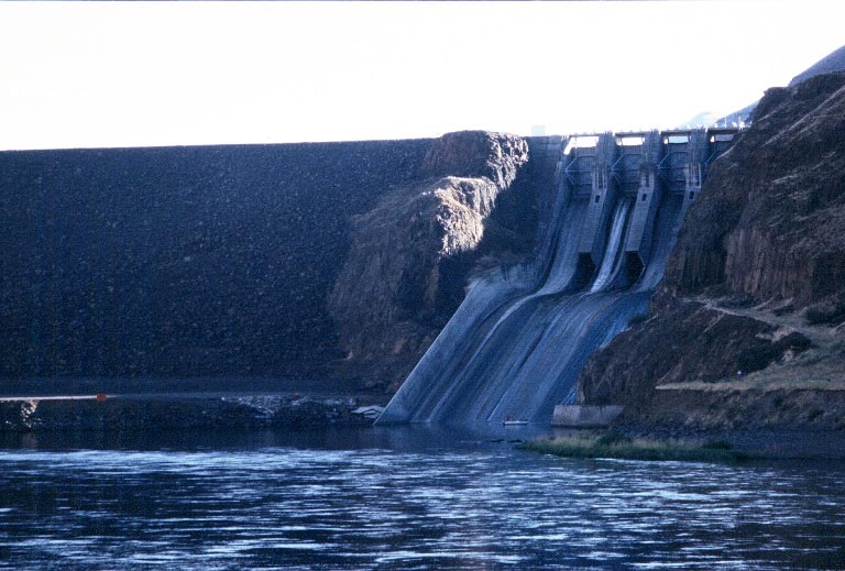
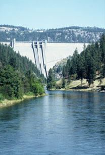
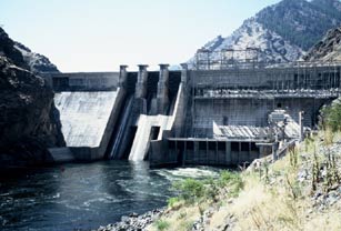
John Day Dam
 Location: On the Columbia River, on the border between Washington and Oregon near Biggs, Oregon.
I'd visited this dam on previous trips so I didn't stop on this occasion except to take this picture from the side of the river opposite from the side I usually see it from.
Spokane, Washington
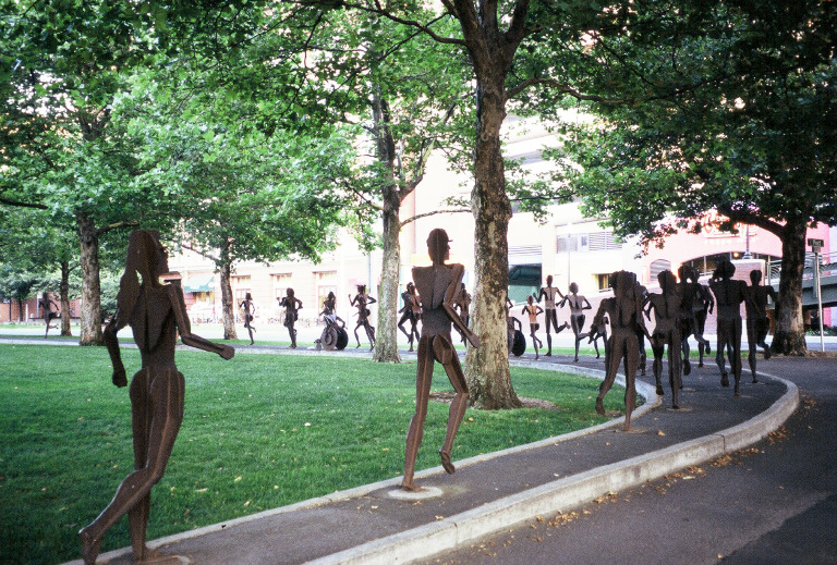
 This is an interesting sculpture by David Govedare at the Riverfront Park in Spokane. Walking near it I kept thinking that the running people were real. A local newspaper says, "Don't miss the marvelous metal sculpture at the southwest corner of the park. Entitled, 'The Joy of Running Together,' it's in honor of the city's annual Bloomsday run each May and consists of 39 full-size running figures and two people in wheelchairs competing in a race."
Boundary Dam
 Location: On the Pend Oreille River, near Metaline Falls, Washington.
This is it -- my favorite dam in the world!
Pend Oreille means "to hang from the ear". I'm told that it's pronounced "pond-ah-ray". Someone actually named one of the local paper mills Ponderay Newsprint; I guess they didn't want there to be any confusion about the pronunciation.
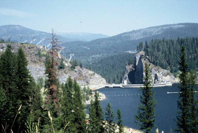
This picture of the dam is looking downstream which, in this case, is north. The two mountains you can see in the background are in British Columbia, Canada. You can see that the dam is sited where the river is constricted in a narrow canyon.
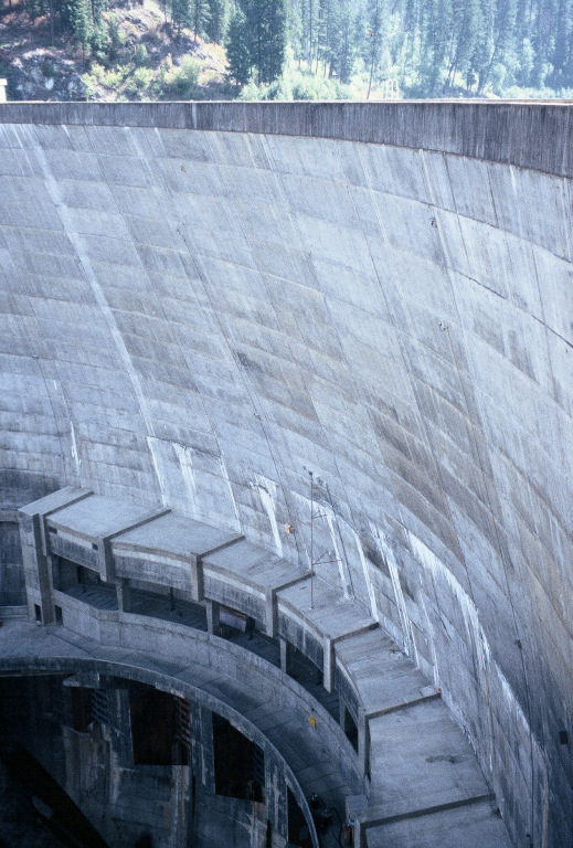
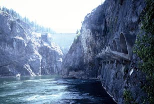 This picture shows a view of the dam taken from downstream looking back upstream at the dam. Along the right cliff are the openings in the canyon wall where the electrical power lines come out of the generator room and go up the cliff to the transmission lines. The entire powerhouse is inside the cliff in an enormous room carved out of solid rock. You can also just see one of the spillway ramps to the left of the dam. When water is released through the spillway the ramp projects it out into the middle of the riverbed so that it doesn't erode the canyon walls.
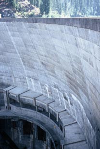 This dam is just incredibly graceful. It's a thin arch dam with variable radius curves not only in plan, but also in section. The thin concrete arch is 340 feet high -- 32 feet thick at the base and 8 feet thick at the crest. If this were a gravity dam (like Hoover Dam) rather than an arch dam it would have to be more than 300 feet thick at the base. The economy of material in the arch is incredible. Furthermore, the arch in the section view causes the crest of the dam to lean downstream out over the river below. If I'm not mistaken the downstream edge of the dam crest is 60 feet downstream from the upstream edge of the dam's base. You can see the overhang in this image.
 You may have noticed some structures on the downstream face of the dam. These are located where you might normally find a dam powerhouse, but since (as mentioned above) the powerhouse is located inside the abutting cliff they're not the powerhouse. What this dam has is six doors or gates covering openings, called "sluiceways", built into the dam structure. These six sluiceways have steel doors covering openings that go right through the dam. Their purpose is to make it possible to open the doors and thereby completely empty the reservoir behind the dam in 24 hours. Each of these sluiceways is 17 feet wide and 21 feet high. There is a mine underground under the reservoir and it was a requirement when the dam was built that it be possible to empty the reservoir if the mine should flood.
For more information about the dam as well as tours of the dam visit Seattle City Light (the dam's owner/operator) at
http://www.seattle.gov/city-light/in-the-community/tours-and-education/boundary-tours
.
There's another picture and description of this dam (from my first visit to this dam in 1993) on my "water" web page.
Box Canyon Dam
Location: On the Pend Oreille River, near Ione, Washington.
I also visited the Box Canyon Dam on this trip but I didn't take any pictures of it. It sits at the far upstream end of the reservoir behind the Boundary Dam.
Dworshak Dam
 Location: On the North Fork of the Clearwater River near Orofino, Idaho.
The scale of this dam is deceptive, both visually and officially. There are any number of ways to measure the height of a dam. The two most useful are referred to as
"structural height"
and
"hydraulic height". Hydraulic height is the difference between the lowest point in the original streambed and the maximum controllable water surface behind the dam. Structural height, on the other hand, is the distance between the lowest point in the excavated foundation and the top of dam. Clearly two dams might have an equal hydraulic height while one of them has a higher structural height either because it has a deeper foundation or because it has more height above the waterline of the reservoir behind it. It's my opinion that dams should be compared by their hydraulic height since that's the part of the dam doing the work.
This whole issue arose because I heard something interesting during my tour of Dworshak Dam. It was explained that Dworshak Dam is actually higher than Hoover Dam but that due to political rivalry Dworshak Dam was measured in a different way so that Hoover would still be listed as higher. According to the United States Bureau of Reclamation web site, the structural height of Hoover is 726.4 feet and its hydraulic height is 576 feet. The US Army Corps of Engineers lists the height of Dworshak as 717 feet, without indicating whether this height is structural, hydraulic, or otherwise. The story, as I heard it, is that Hoover measures their structural height from the bottom of their foundation while Dworshak was ordered to measure their height from the floor of their lowest gallery so that Hoover would be officially "higher". What is the true structural and/or hydraulic height of Dworshak Dam?
In July of 2007 I saw on a web page of the US Army Corps of Engineers for the Dworshak Dam (no longer available) explicit values for the structural and hydraulic height of Dworshak Dam.
|
|
Dworshak Dam
|
Hoover Dam
|
|
hydraulic height (feet)
|
632
|
576
|
|
structural height (feet)
|
717
|
726.4
|
In terms of the water it holds back, Dworshak Dam is 56 feet higher than Hoover Dam.
Brownlee Dam
 Location: On the Snake River, on the border between Idaho and Oregon.
The Brownlee Dam is the uppermost of three dams on the Snake River that function as a single electric generating unit. The three dams are the Brownlee (upstream), Oxbow (middle), and the Hell's Canyon (downstream).
Originally, there were two competing plans for how to utilize the electric generating potential of this section of the Snake River. One plan was for the federal government to build a single high dam with public funds that would create a large reservoir. The other plan was for Idaho Power to build three smaller dams which would inundate less of the land along the river. The three-dam plan was adopted.
The three dams function as a single electric generating unit because the reservoirs behind the Hell's Canyon and Oxbow dams are too small to store water for power generation. Only the reservoir behind the Brownlee Dam is large enough to store water from the spring run-off and save it to generate power during the following winter. Therefore, if a gallon of water goes through the powerhouse at the Brownlee Dam then it is necessary that a gallon also go through the powerhouses at the Oxbow and the Hell's Canyon Dams as well. If it didn't then the level in those two lower reservoirs would rise immediately and begin to flood the shoreline. It's not as exact as this. When I was camping along the Hell's Canyon reservoir I saw the water rise three inches in two hours and then fall seven inches by morning. There appears to be a foot or so of flexibility but essentially (and on average each day) whatever water goes through one of the dams has to go through all three of the dams.
Oxbow Dam
 Location: On the Snake River, on the border between Idaho and Oregon.
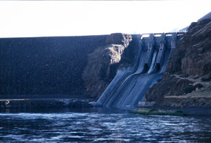
The Oxbow Dam is the middle member of the three-dam complex on the Snake River. Oxbow is interesting not so much for the dam but for the unusual configuration of its powerhouse. Oxbow is named for the three-mile long bend in the Snake River that's shaped like the U-shaped frame that went over an ox's neck when it pulled a wagon. Essentially, the river turns 180 degrees and comes back parallel to itself. The dam is located on the upstream side of this loop and the powerhouse is located on the downstream side. Water from the reservoir gets to the powerhouse through two tunnels cut through the hill that separates the two sections of the river flowing in opposite directions. (This is confusing. Maybe I'll draw a picture at some point.)
The other interesting thing about this dam (which actually does have to do with the dam) is that it has an overflow spillway that has a rock-fill "plug". This plug (rather than the main dam) is what is shown in the accompanying picture. If the river floods so much that the regular spillway release gates can't handle the flood then the river will rise until it begins to flow over this small "dam" of rocks. If the flow over this small dam on the secondary spillway is high enough then that small "dam" of rocks will wash away allowing more water to go down that spillway and thereby saving the main dam. I'd never seen anything like this before and it took a while to figure out what it was (with some help from the operators at the powerhouse).
I had a very interesting and informative personal tour of the powerhouse. I want to thank the engineer that took the time to show it to me, but (unfortunately) I didn't catch his name. If you're the guy and you happen to read this then I'd like to hear from you.
Hell's Canyon Dam
 Location: On the Snake River, on the border between Idaho and Oregon.
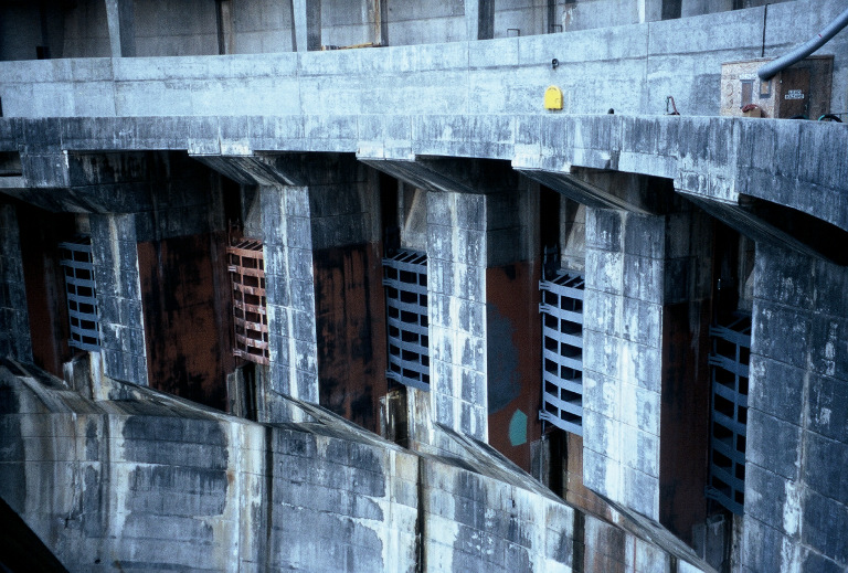
The Hell's Canyon Dam is the lowest (i.e., most downstream) of the three-dam complex on the Snake River. The unusual thing about this dam is that there was so little room at the site that there wasn't space for the electrical switching yard (usually built on level ground adjacent to the dam) so they had to build it right on the face of the dam above the powerhouse. That's why you see all that steel on the right side of the dam. Normally, that would all be up on the ground above the dam.
Immediately below the dam is the put-in for the people that kayak and raft the Snake River through the Hell's Canyon National Recreational Area. Each group that puts into the river has to stop and check at the visitors center to find out how much water is going to be released through the dam that day since this materially affects their upcoming experience on the river. I presume that the people on the river would like the water volume to be constant over the course of the day. The electrical generators, however, would like to generate a lot of power (and consequently release a lot of water) at the times of peak electrical load and to generate less power (and consequently release little or no water) at times of low electrical load. The compromise is that they've established water flow parameters. On the day I visited the dam the rafters were told that the minimum flow would by 6,000 cubic feet per second (CFS) with a maximum of 21,000 CFS and an average over the day of 9,000 CFS. There's also a parameter for how much it can change over the course of an hour.
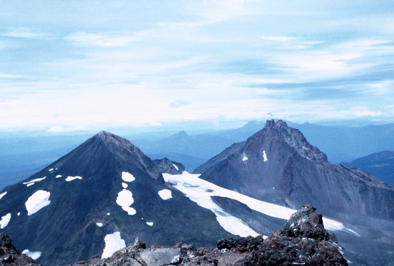
South Sister
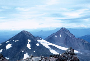 At 10,358 feet South Sister is third tallest mountain in Oregon and is the tallest of the group of volcanoes called the Three Sisters. The trail up the mountain is fairly steep and difficult, but "climbing" is not required. The hike is 11 miles round-trip, with 4,900 feet of elevation gain. I reached the top and took this picture showing a view from the summit looking north towards (I believe) Middle Sister and North Sister.
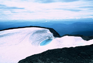 This picture is a view of the crater at the top of the mountain. I did this trip in August and it was quite cold at the summit; there were glaciers on the upper mountain. The climb was difficult for me. By the time I was ascending the final steep section (at 10,000 feet) I could only take about ten steps before I had to stop to catch my breath. Clearly I'm not in shape. But I'm really glad that I was encouraged to continue and that I made it to the top.
I hadn't made the top of a mountain since I'd hiked
Mount Washington
(6,288 feet) in New Hampshire as a teenager. Mount Washington is more interesting than its modest height suggests. At
http://www.mountwashington.com/weather/index.html
it is reported that on Mount Washington "hurricane-force winds occur every third day (on average). And it was here ... where the world's highest wind speed ever was recorded: 231 MPH".
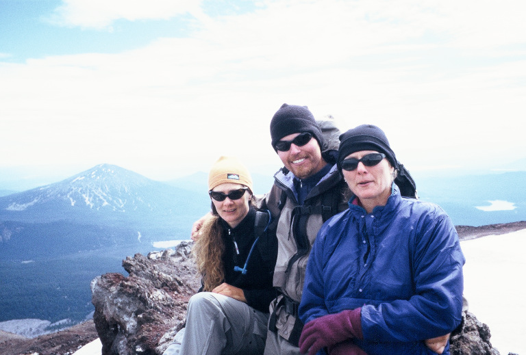
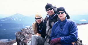 These were my climbing companions on the hike up South Sister: (left to right) Kyra Rice, Michael Vinton, and Laurie Rice. I owe a debt of gratitude to Kyra for encouraging me to continue when I thought I couldn't go on and to Laurie and Michael for inviting me along and tolerating my pace.
Links to South Sister on the web:
There is a photo of South Sister from Moraine Lake at
http://www.oregonhiking.com/photos/285.htm.
There are a number of pictures of South Sister and its neighbors at
http://vulcan.wr.usgs.gov/Volcanoes/Sisters/images.html.
 Location: On the Columbia River, on the border between Washington and Oregon near Biggs, Oregon.